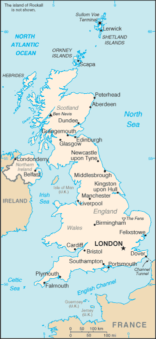
The UK is made up of:
- Great Britain (the formerly separate realms of England and Scotland, and the principality of Wales. )
- Northern Ireland (also known as Ulster)
- Numerous smaller islands including the Isle of Wight, Anglesey, and the Scilly, Orkney, Shetland, and Hebridean archipelagos.
Where is the UK?
The UK is an island nation in Western Europe
just off the coast of France. The mainland areas lie between latitudes
49°N and 59°N and longitudes 8°W to 2°E.
The UK lies between the North Atlantic Ocean and the
North Sea, and comes within 35 km (22 miles) of the northwest coast of
France, from which it is separated by the English Channel. Northern
Ireland shares a 360 km international land boundary with the Republic of
Ireland. The Channel Tunnel bored beneath the English Channel, now
links the UK with France.
How big an area does the UK cover?
The UK has a total area of approximately 245,000 km², almost a quarter-of-a-million square kilometres.| Interesting Fact |
| No one in the UK lives more than 120 km (75 miles) from the sea. |
Seas surrounding the UK
The UK is made up of several islands. The only land border connecting the UK to another country is between Northern Ireland and the Republic of Ireland. The UK is bordered by four seas:
- to the south by the English Channel, which separates it from continental Europe
- to the east by the North Sea
- to the west by the Irish Sea and the Atlantic Ocean
 The Land
The UK Landscape is very varied, ranging from the Grampian Mountains of Scotland to the lowland fens of England which are at or below sea level in places.
Scotland and Wales are the most mountainous parts of the UK. A ridge of hills, the Pennine,
runs down the centre of northern England. Many coastal areas are
low-lying, especially in the east and south of England. These include
the wetlands of the Somerset levels, that regularly flood during heavy
rain.
Most of the UK is made up of gently rolling hills with isolated areas of high ground such as Dartmoor in the south-west of England or the Mourne Mountains in Northern Ireland.
Lakes
Northern Ireland is also home to the UK's largest lake,
Lough Neagh, which covers an area of 396sq.km (153 sq miles). Other
major lakes include Windermere in the English Lake District and Loch
Lomond in Scotland. Another of Scotland's lakes, Loch Ness is famous for
sightings of 'Nessie', a mythical monster!
UK Rivers
Being a relatively small Island, the UK's rivers are not very long. The Severn,
its longest river, is just 338 km in length, beginning in Wales and
entering the Atlantic Ocean near Bristol in England. Other major rivers
include the Thames,
which flows through Oxford and London, and the Trent and Mersey rivers,
which drain rainfall from large areas of central England.Find out more about UK Rivers
Climate
The UK's climate varies greatly according to season and location, but on the whole can be described as mild with few extremes.Find out more about the climate
Facts
- The capital of England is London. Sometimes referred to the capital of Britain. London is built along the River Thames
- Three quarters of the land in Britain is used for farming.
- Nine out of ten people live in towns and cities.
- The highest mountains are in Scotland and Wales.
- More than two-thirds of people own their own homes.